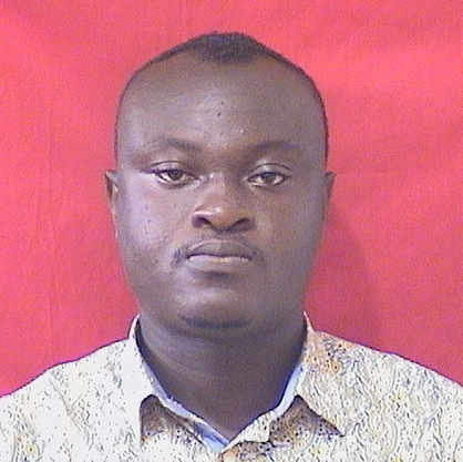
Profile
I am Joseph Beneth Kankam, a passionate Geomatic Engineer hailing from Techiman in the Bono East Region of Ghana. Born on November 14, 1994, I have dedicated my professional journey to the field of Geomatic Engineering, specializing in Geographic Information System (GIS), satellite navigation, and deformation monitoring technology.
My academic journey commenced at Mfantsipim School in Cape Coast, where I pursued General Science and obtained my WSSCE Certificate in 2013. Following my passion for geospatial sciences, I furthered my education at Kwame Nkrumah University of Science and Technology (KNUST), earning a Bachelor of Science in Geomatic Engineering from 2014 to 2018. During this time, I delved into diverse disciplines such as Photogrammetry, Remote Sensing, Cartography, and Cadastral Surveying.
Eager to deepen my expertise, Ihave completed my Master of Philosophy in Geomatic Engineering at KNUST, focusing on Geographic Information System (GIS). My thesis, "Spatio-Temporal Analysis of Urban Green Space and Wetland Degradation in Greater Kumasi," reflects my commitment to addressing environmental challenges through geospatial technologies.
Professionally, I have served in various capacities, starting as a pupil teacher at Fountain International School, Techiman, before venturing into the dynamic field of Geomatics. From August 2015 to August 2019, I gained valuable experience as an Assistant surveyor at Geodecon Survey Limited and the Department of Urban Roads, Techiman, honing my skills in land and engineering survey.
In August 2018, I embraced the role of a Teaching and Research Assistant at KNUST's Department of Geomatic Engineering. Here, I contributed to the academic growth of students, assisted in practical lessons, and analyzed survey reports and maps.
Since March 2021, I have had the privilege of serving as a Senior Technician and Surveyor in the same department, overseeing practical sessions for surveying courses, maintaining surveying equipment, and supporting students in their research endeavors. I am committed to staying abreast of industry advancements, as demonstrated by my active involvement in organizing workshops to enhance students' practical skills.
Beyond academia, I am an advocate for teamwork, having worked collaboratively in research and project teams. As the President of the Association of Geomatic Engineering during the 2016/2017 academic year, I successfully bridged communication gaps between lecturers and students, fostering improved relations within the academic community.
My research interests include satellite navigation, topographic modeling, and spatiotemporal analysis, reflecting my dedication to leveraging geospatial technologies for societal and environmental benefit. Outside of academia, I enjoy 3D visualizing, engineering surveying, and spatial data collection and analysis.
Professionally, I am a proud member of the Ghana Institution of Surveyors, holding a Professional membership since February 2023. Additionally, my technical skills encompass various software applications, including Microsoft Office, Topcon, Trimble Business Centre, CAD software, LISCAD, ARCGIS, QGIS, and Erdas.
In my free time, I engage in artistic pursuits such as 3D visualizing, contributing to my holistic approach to problem-solving in the field of Geomatic Engineering.
As I continue my academic and professional journey, I am driven by a commitment to excellence, innovation, and the application of geospatial sciences for the betterment of society.
Interests:
-
Satellite Navigation: Exploring the application of satellite technology in precise positioning and navigation systems.
-
Positioning and Deformation Monitoring Technology: Investigating methods to monitor and analyze changes in the earth's surface for various applications
-
Topographic Modeling: Using geospatial data to create accurate and detailed representations of the Earth's surface.
-
Spatiotemporal Analysis: Examining the relationships between space and time in geographical phenomena for insightful analysis.
-
Photogrammetry: Employing photographic data to make precise measurements and create 3D models of objects or landscapes.
My professional journey and academic pursuits reflect my commitment to the advancement of geospatial sciences and their application to address contemporary challenges. I look forward to contributing further to the field and making a positive impact on society.

